
My alarm went off at 3 a.m.
I am not a morning person. Getting up for sunrise is always tough… but 3 a.m. and a 3-hour drive to a location? Damn near impossible.
I stumbled out of bed, got dressed, and got on the road as quickly as I could. I knew if I let myself think about it, I’d jump back under the covers.
Driving through the dark leaves me alone with my thoughts instead of considering the passing scenery. I’ll spare you those details.
As I left the Columbia River Gorge and made my way into the Tygh Valley (pronounced “tie”), I was surprised to be greeted by the ever majestic outline of Mt Hood, which I could just barely make out as blue hour began to lift the shadows of the landscape.
For a moment, I was very tempted to pull off to the side of the road and set up a shot of the mountain.
However, seeing the developing light over my original destination pulled me back on course to what I had planned.
I rolled into White River Falls State Park and was immediately surprised by its small size, as it basically consists of a parking lot, a few picnic tables, and an overlook.
As soon as I stepped outside my vehicle, the sound of the falls instantly made my heart sink.
I HAD MADE A HUGE MISTAKE!
The river was flowing TOWARDS sunrise, not away from it. This meant that the beautiful color in the sky would not be right behind and above the falls like I had visualized it in my mind.
I stood there for a solid two minutes, dumbfounded that I had somehow missed this critical detail when researching this location.
The rapidly changing light brought me back to reality and put me into scramble mode to try to salvage something from the morning.
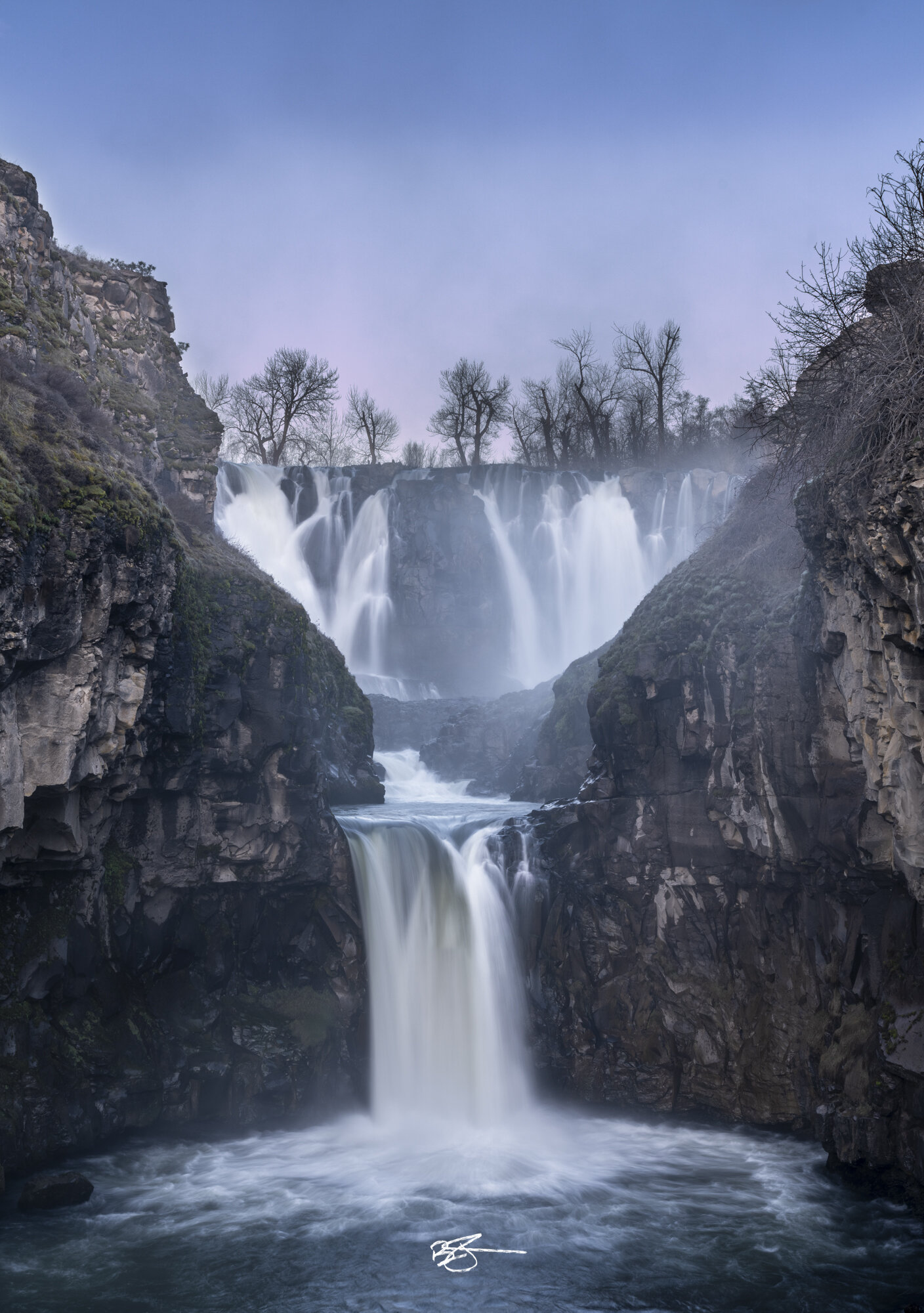
As I walked toward the falls, the steady roar increased to an almost deafening level. From the overlook, the upper falls immediately grabs your attention as it plummets 75 feet with immense power. So much so, in fact, that this site was home to one of Oregon’s earliest hydroelectric projects which operated from 1910 to 1960. The remnants of the powerplant can still be seen and are visible in one of my photos as well.
As my gaze drifted to the left down the canyon I could see the second waterfall, named Celestial Falls, drop 40 feet to a pool below before the churning water continued downstream through the picturesque gorge.
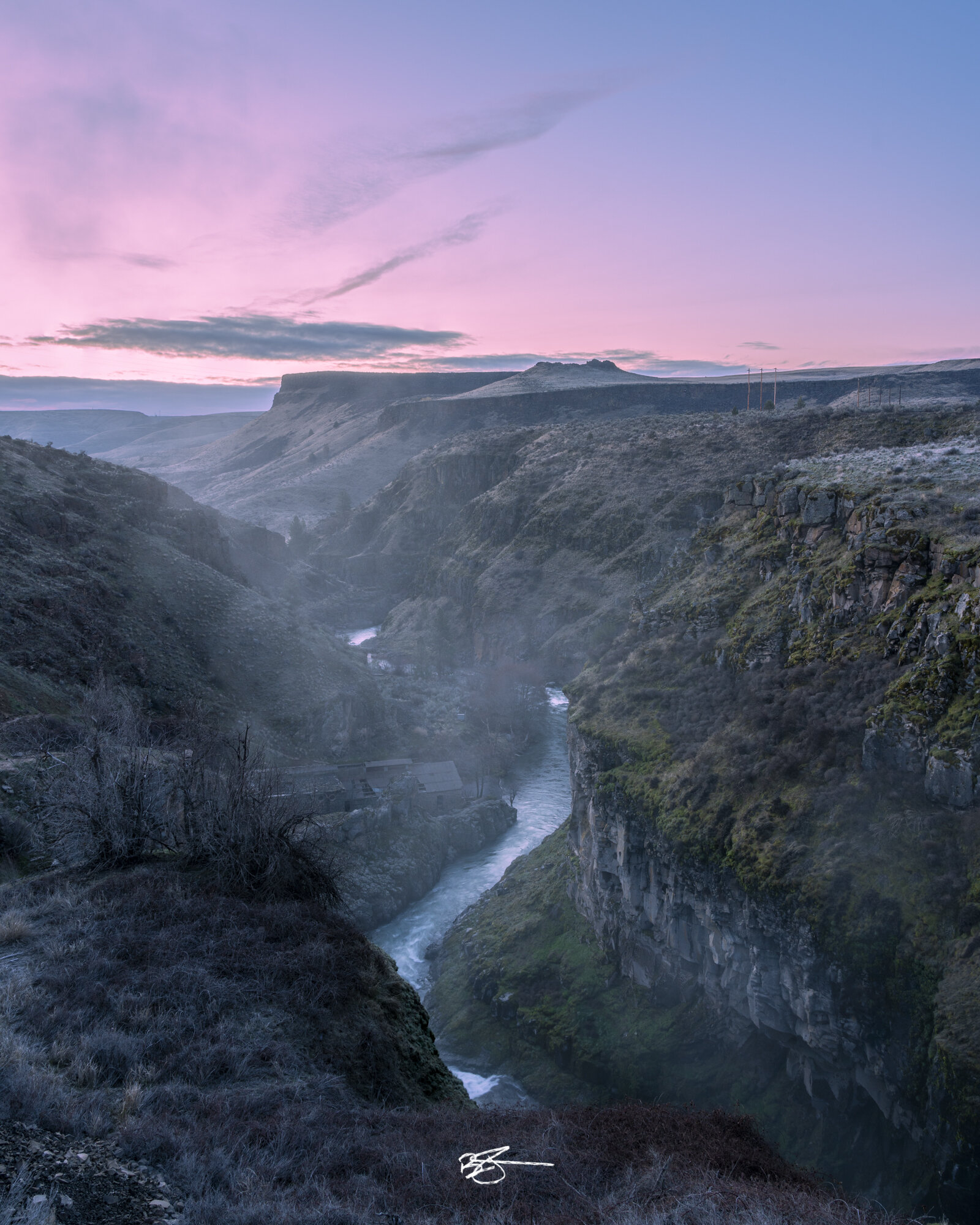
The light back to the east was so good.
Unfortunately, the best of it was blocked by a nearby hill though the scene behind the canyon was still bathed in a soft glow.
I quickly set up my camera and dialed in a composition of the canyon looking away from the falls and towards sunrise. I placed the river in the center of the frame, using it as a leading line to guide the viewer’s eye through the image.
Given that I had a foreground relatively close to the camera, I took three exposures focused at different areas through the composition. During post-processing, this would allow me to blend the 3 frames together to ensure that the final image was sharp from front to back.
With the light ever-changing, I packed up and headed down the trail into the canyon to set up a shot of the two waterfalls, looking back up the canyon.
Even though it was a short hike, by the time I was set up for my second composition the pink and blue glow behind the falls was pretty much gone. Disappointed, I fired off a few shots before heading back up the trail.
With the sunrise light gone and the early morning sun taking over, I got out the drone and flew around the falls to get some aerial footage for my video. The perspective from above is quite striking as well and looking towards the west you can see Mt Hood rising in the distance.
There is quite a bit of beauty packed into this small state park.
With the drone footage captured, it was time to make a decision about the rest of my day. Do I stick around to see if I can get a better shot for sunset, or do I continue on to explore new locations?
Originally, my plan was to explore the nearby Lower Deschutes Scenic Byway and spend the night camping on the Deschutes River.
However, the temptation of Mt. Hood was just too strong and I decided to attempt to find a composition of the 11,250 ft. stratovolcano looking west into the sunset from the Tygh Valley.
Armed with my maps from Gaia GPS, I set off down the backroads of Wasco County searching for a great view of the mountain, but it never came.
Six hours of driving took me from the Tygh Valley, to the foothills of Mt. Hood, and all the way around the eastern slopes back into the Columbia River Gorge and into the Hood River Valley. At every turn I was stifled by Forest Roads closed for the winter due to snow, private property and numerous dead-ends absent the views I was hoping for.
In the end, the weather made it all a moot point as large banks of clouds rolled in at lower elevations, completely obscuring the mountain from view.
Tired from an early start and a lot of driving, I made the 3-hour trek back to basecamp in the Willamette Valley.
In situations like what I experienced on this day, it’s always hard to judge results while in the field. After all, grabbing the exposures is only half the battle. Getting the files back to the computer and post-processing them is just as important.
I find it very rewarding to be able to coax a decent image out of exposures that I originally wasn’t too optimistic about, and that was the case here again on this adventure.
It’s another reminder that I need to trust my skills in the field, take the time to capture the most technically perfect exposure I possibly can, and give myself a solid foundation to work from during post-processing.
While this trip was absolutely exhausting to pack into a single day, I’m glad I made the effort. White River Falls is absolutely stunning and worth a visit if you’re ever in Oregon.
The Images
Watch the Video
I hope you enjoy these images and the video. If you do, please consider supporting my work in some way:
Subscribe to my newsletter for email updates
Share one of my videos with a friend who might appreciate it
Thank you in advance to everyone who chooses to support me in some way!